Scenery from an airplane window

Golf Course

Aerial photography of rice paddies after rice planting using a drone

Shooting the harvest of new rice with a drone

Aerial photography of rice paddies after rice planting using a drone

aerial photograph

Aerial view of Shinjuku from above Hatsudai, Shibuya Ward, Tokyo

Streets of Kita Ward, Tokyo

Aerial view of Yamagata City Hall

Aerial view of the Harumi area in Chuo Ward, Tokyo

Aerial view of Azabu-Juban from above Minami-Azabu, Minato-ku, Tokyo

Aerial view of Shinjuku cityscape from above Shinjuku Central Park

Aerial view of the Roppongi area in Minato Ward, Tokyo

Aerial view of Minato Ward, Tokyo

Tokyo sky, clouds and gaps

Aerial view of Akabanebashi intersection in Minato Ward, Tokyo

Aerial view of the Yurakucho Station area

Aerial view of Shiba Park from above Hamamatsucho Station

Aerial view of Shinjuku from above Hatsudai, Shibuya Ward, Tokyo

Aerial view of Shiba Park from above Hamamatsucho Station

Aerial view of the cityscape around Roppongi, Minato Ward, Tokyo

Aerial view of Tsukishima from above Tsukuda Bridge in Tokyo

Aerial view of the Harumi area in Chuo Ward, Tokyo

Aerial view of Jingu Stadium from above Minami-Aoyama 3-chome

Aerial view of Minato Ward, Tokyo

Aerial view of Minato Ward, Tokyo

Aerial view of Minato Ward, Tokyo

View of Kita Ward and the Sumida River

Aerial view of the Yamagata Expressway near Yamagata Kita Interchange

Aerial view of Yamagata City Hall

Aerial view of the upper reaches of the Tedori River in Ishikawa Prefecture

Aerial view of the upper reaches of the Tedori River in Ishikawa Prefecture

Aerial view of the upper reaches of the Tedori River in Ishikawa Prefecture

Aerial view of the upper reaches of the Tedori River in Ishikawa Prefecture

Chubu Centrair International Airport aerial view

Curly clouds and blue sky

Summer morning radio exercise (after image quality correction)

Aerial view of Itoman city

Aerial view of Itoman city

Naha cityscape seen from above

Mount Fuji b

Okinawa coastline and farmland from the air 2017

Kitakami River Waterfront

Kitakami River Waterfront②

View of Morocco before arriving at Casablanca airport

View of the port of L'Estaque in Marseille from the plane

Kitakami River Waterfront③

Office workers gathering outdoors to talk

Scenery from an airplane window

New Chitose Airport from the plane

Maldives 2

Aerial view of Takagicho from above Hiroo

Aerial view of the Ebisu Garden Place area

Aerial view of Moriya Station on the Tsukuba Express

Arrived in the northern land

Climbing Mt. Aso (Takaoka / Nakadake) "Aerial view of Nakadake crater"

Hanshin Racecourse and Takarazuka Golf Club

Shizuoka Prefecture Hamamatsu City Station North Street

Drone blue sky

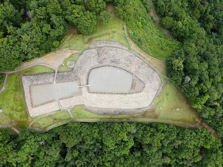
Aerial view of Mori Shogunzuka Tomb in Chikuma City, Nagano Prefecture

Group photo of company employees standing outside

Group photo of company employees standing outside

Aerial photo of Okinawa prefecture Naha Airport after takeoff

Aerial photo of Okinawa prefecture Naha Airport after takeoff

Group photo of company employees standing outside

Aerial photo of Okinawa prefecture Naha Airport after takeoff

Aerial photo of Okinawa prefecture Naha Airport after takeoff

Group photo of company employees standing outside

Aerial photo of Okinawa prefecture Naha Airport after takeoff

Aerial photo of Okinawa prefecture Naha Airport after takeoff

View from Tokyo from Musashi Kosugi 2

Night view of Tokyo

Take an aerial survey of the construction site with a drone

Aerial view of Shizuoka Station area

Aerial view of Shizuoka Station area

Aerial view of Shizuoka Station area

Air travel

Aerial view of Shizuoka Station area

Aerial view of the area around the Susono Interchange on the Tomei Expressway

Aerial view of Mt. Fuji from above Shimizu Port

Aerial view of Shizuoka Station area

Aerial view of the area around Seiseki-Sakuragaoka Station on the Keio Electric Railway

Aerial view of Hokko Junction on the Hanshin Expressway Bayshore Line

Aerial view of the Nanko area from above the Konohana Bridge

Aerial view of the Maishima Waste Disposal Plant

Aerial view of the area around Seiseki-Sakuragaoka Station on the Keio Electric Railway

Aerial view of the west exit of Yamagata Station

Aerial view of Tochigi Station area

Aerial view of the area around Koga Station on the Tohoku Main Line

Aerial view of the west exit of Yamagata Station

Aerial view of the Okegawa Kitamoto Interchange area

Aerial view of the Yamagata Kaminoyama Interchange area

Aerial view of Utsunomiya Station

Aerial view of the west exit of Yamagata Station

Aerial view of the area around Motomiya Station on the Tohoku Main Line

Aerial view of the area around Fukamachi, Yamagata City

Aerial view of the Okegawa Kitamoto Interchange area

Digital art aerial photography People passing by 3

Sea_ripple pattern_78

Streets seen from the top of the mountain
25125 Free images about .
Need a image or photo ? Find the best free stock images about .
Download all images and use them even for commercial projects.


 © 2011 - 2025 ACworks Co.,Ltd. All rights reserved.


